Rainfall this season:
The summer season rainfall is measured from 1 July every year. July has the lowest rainfall on average of all the months in the Senwes area, with an average of 2 millimetres. The average rainfall during July of this year in the Senwes area was 46 millimetres. It is said that good rains during the winter usually result in lower rainfall figures in mid-summer. There has been four seasons since 1904 during which more than 35 millimetres of rain fell during July on the Highveld, namely during the 1918/19, 1939/40, 1943/44 and 1957/58 seasons. Above average rainfall was received during all four seasons. The 1943/44 season was the wettest season on the Highveld since the measurement of rainfall commenced.
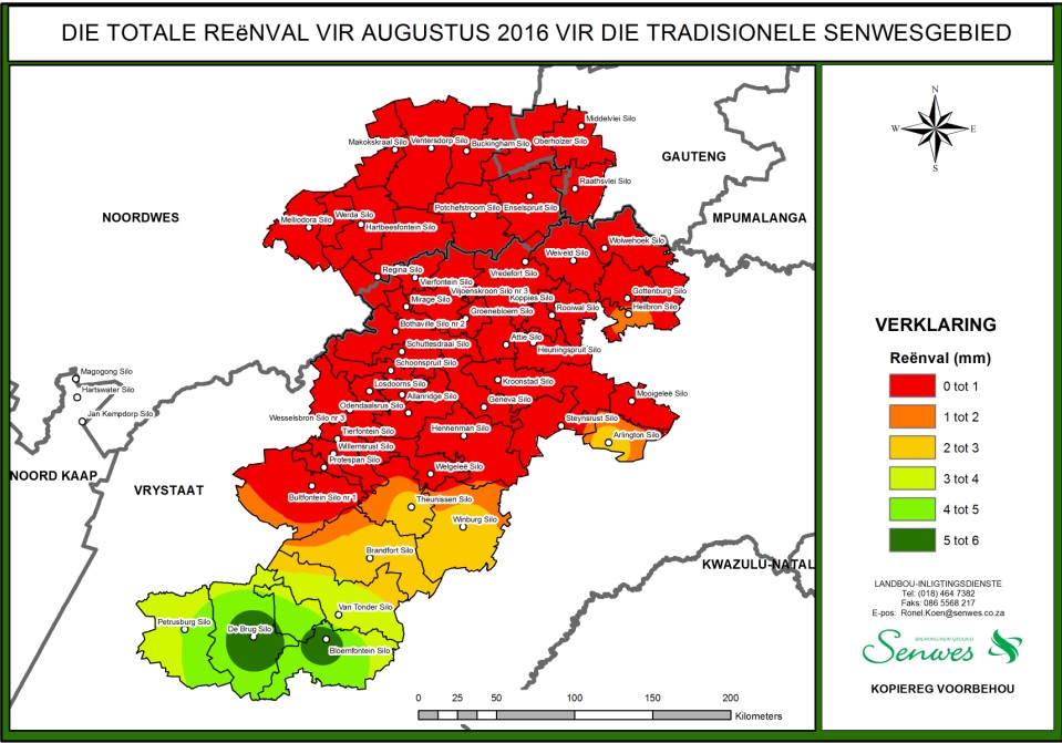
No rain was received over the largest part of the Senwes area during August. See the map below.
Above average rainfall was received during the first two months of the season over the traditional Senwes area of operation. Districts in the Senekal area received the highest rainfall in history for July.
The map below reflects the areas where good rainfall was received over the past two months. This rain contributed hugely towards the soil moisture conditions over a reasonably large area of the traditional Senwes area of operation, which in turn contributes towards optimism for a better season.

Prospects for the 2016/2017 season:
There has been a number of negative reports in the news about the climate prospects for the coming season. However, not all weather forecasting services agree with these negative reports. Let's take a look at the most important climate indicators.
Meteorologists base their predictions for the coming season on a number of indicators. The Southern Oscilation Index is one of the important indicators and indicates the direction of wind in the central part of the Pacific Ocean. When the index is negative, it means that the winds in the central Pacific Ocean mainly blow from Australia to South America. This results in warmer sea temperatures in the NINO3-4 area. It is not usually good news for the expected rainfall for the summer season in South Africa. The index is fairly constantly close to zero at present, which is not overly concerning.

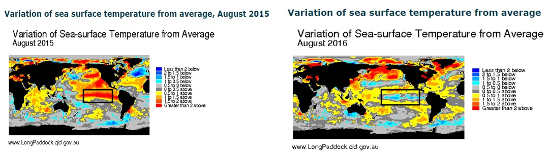
What is happening to the sea temperatures in the NINO3-4 area in the Pacific Ocean is even more important. When the average sea temperature of the area is warmer than normal, it means that it is having a certain impact on the moisture circulation patterns of the world, which normally has a negative impact on the expected rainfall over Southern Africa. We are very optimistic about the fact that the sea temperature in the NINO 3-4 area is cooling down. We are coming from a period during which the sea temperatures in this area were the highest in many years and we experienced a very strong El Niño-episode with poor yields in the western parts of the summer rainfall area.

The variance of the sea temperature in the NINO 3-4 area is indicated in the two maps below. The sea temperature variance of the previous season (August 2015) is indicated, as well as the Augustus 2016 sea temperature variance. It is evident that the sea temperature in the NINO 3-4 area is much lower than the previous season. The chances of the development of a strong La Niña-type season this year are fairly good. As experienced in the past, La Niña-type seasons have rendered better crop yields than El Niño-type seasons on average.
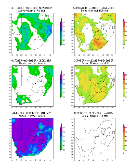
It is concerning that most weather prediction services indicate a late rainfall season, namely that it will only commence at the end of November. The poor condition of our natural and planted grazing and the low water levels of our most important dams are concerning. The maps below were provided by the South African Weather Service and reflect the expected rainfall for the coming season. The expected trend in respect of spring rain is shared by various weather prediction services. We hope, however, that the summer rain will arrive earlier.
Summary and conclusion:
There is reason for optimism about the coming season. In most instances we have better underground moisture conditions and indications are that we are moving away from the recent El Niño-episode. However, we are concerned about the predicted late commencement of the rainy season. We pray, hope and trust that there will be relief after the very dry conditions experienced by most producers over the past few years.
Article written by Thys Grobbelaar, Senior Grain Analyst, Senwes Grainlink on 8 September 2016